

Master plan rendering helps real estate developers, urban planners, architects, and landowners visualize large-scale developments before construction begins. Through photorealistic 3D visualization, technical site plans become detailed images showing how neighborhoods, roads, parks, commercial centers, and public spaces will work together.
For a master-planned community, a single building rendering is rarely enough. Developers need to communicate the entire development vision: residential neighborhoods, open space networks, infrastructure, amenities, and the relationship between individual phases.
Aerial master plan renderings, neighborhood perspectives, and architectural animations can make these complex relationships easier to understand.
Whether the project is a master-planned residential community in Texas, a mixed-use district in Florida, or a resort development in Colorado, realistic 3D visualization helps present the proposed environment to investors, municipal reviewers, development partners, and future residents.
At Mindness, we create architectural visualizations using project drawings, 3D models, site plans, and design references. Our site plan rendering services help project teams communicate building placement, landscape organization, and the intended character of proposed developments.
In this guide, we explain the essential types of master plan renderings, their applications in US real estate development, how phased visualization works, what affects production costs, and how to prepare a large-scale project for 3D visualization.
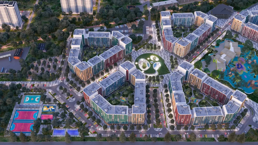
What Is Master Plan Rendering?
Master plan rendering is the process of creating realistic 3D images of an entire planned development, showing the relationships between buildings, streets, open spaces, amenities, and surrounding land.
Unlike a traditional two-dimensional master plan, which communicates spatial organization through lines, symbols, and colored land-use areas, a photorealistic rendering illustrates how the future development may look and feel.
Master plan visualization can show:
- Residential neighborhoods and building arrangements.
- Town centers, retail districts, and mixed-use developments.
- Roads, pedestrian connections, and bicycle routes.
- Parks, green corridors, plazas, and public spaces.
- Schools, community facilities, and recreational amenities.
- Water features, topography, and surrounding landscapes.
- Proposed building density and architectural character.
- Individual development phases and the overall buildout vision.
These images can be created during concept planning, entitlement, design development, or pre-construction marketing.
The level of detail depends on the project’s stage and the intended audience.
A conceptual master plan rendering may use representative architecture to illustrate a development vision. A planning-oriented visualization may require closer coordination with current drawings, site information, and technical exhibits.
Master Plan Rendering vs. Site Plan Rendering: What’s the Difference?
Master plan rendering and site plan rendering are closely related, but they usually address different scales.
A site plan rendering typically focuses on a single property, building group, or smaller development site.
It shows how buildings, parking, access roads, landscaping, and surrounding elements are arranged within the property.
A master plan rendering covers a larger area, such as a residential community, urban district, resort, or multi-building campus.
It emphasizes relationships between neighborhoods, land uses, infrastructure, amenities, and development phases.
| Feature | Site Plan Rendering | Master Plan Rendering |
|---|---|---|
| Geographic scale | Individual property or site | Community, district, or large development |
| Main focus | Building placement and site organization | Overall development structure and connectivity |
| Typical views | Top-down or elevated site views | Aerial overviews, neighborhood and street-level views |
| Development phases | Often one principal stage | Frequently several phases |
| Common audiences | Architects, property developers, planning teams | Master developers, investors, municipalities, homebuilders |
| Primary question | How does the project work on its site? | How will the entire community function and develop? |
Both formats can be useful within the same real estate project.
For example, a master developer may commission a community-wide aerial rendering and then create detailed site plan renderings for individual neighborhoods or commercial parcels.
Explore Mindness Site Plan Rendering Services to learn more about visualization at the individual-site scale.
Why Large-Scale Developments Need Master Plan Visualization
Large developments are difficult to communicate through technical drawings alone.
A master-planned project may involve multiple neighborhoods, different building types, public infrastructure, landscape systems, and construction phases.
Each stakeholder needs to understand a different part of the proposal.
Communicating the Overall Development Vision
Aerial master plan visualization provides a comprehensive view of how the proposed community fits together.
Instead of studying separate diagrams for land use, road networks, and open space, viewers can see these relationships within a coordinated environment.
This is particularly useful when a project includes several residential areas, a town center, schools, parks, and commercial destinations.
A well-composed aerial image can help explain the development’s spatial organization while establishing a recognizable visual identity.
Supporting Planning and Entitlement Reviews
Large-scale developments often require review by planning commissions, city councils, county authorities, and other agencies.
These processes may involve decisions about land use, zoning, development density, infrastructure, open space, and public facilities.
Master plan renderings can help communicate the proposed development clearly during presentations and public discussions.
For planning-oriented images, consistency with current drawings and technical exhibits is essential.
Renderings should accurately distinguish approved elements, proposed features, conceptual architecture, and future development areas.
Visualization can support the review process, but it does not guarantee approval or replace professional planning and engineering documentation.
Explaining Projects to Investors and Development Partners
Master-planned communities frequently require substantial investment before the first neighborhood is complete.
Land acquisition, roads, utility infrastructure, parks, and community amenities may form part of a long-term development program.
A coordinated visualization package helps investors and development partners understand the proposed site organization, community character, and relationships between development components.
Aerial renderings may be particularly valuable for showing the complete site.
Neighborhood perspectives can provide additional detail about building types, open spaces, and the intended pedestrian experience.
These images complement financial projections, feasibility studies, engineering reports, and development schedules.
Supporting Community Engagement
New developments can raise questions about building density, traffic, neighborhood character, public spaces, and environmental impact.
Accessible visual materials make proposed changes easier to discuss.
Aerial images can show the entire development, while street-level perspectives illustrate how specific public spaces or neighborhood edges may appear.
Where relevant, existing-condition and proposed-condition views can help audiences compare the site before and after development.
Public-facing images should clearly identify conceptual elements and should not conceal important physical changes.
Marketing Future Neighborhoods and Amenities
Master-planned communities may begin marketing long before their full buildout.
Photorealistic renderings allow marketing teams to introduce the intended residential environment, community amenities, parks, and neighborhood character.
These materials can support community websites, sales centers, presentations to homebuilder partners, and pre-construction marketing campaigns.
As individual phases progress, more detailed neighborhood and building-specific visualizations may be developed.
Types of Developments That Benefit From Master Plan Rendering
Master plan visualization is useful across several types of large-scale real estate development.
Master-Planned Residential Communities
These developments may combine different housing types with schools, parks, community facilities, retail destinations, and shared amenities.
Aerial master plan renderings show the overall neighborhood structure.
Street-level and amenity perspectives communicate the character of individual areas.
For residential projects, multifamily exterior rendering may also be relevant when apartment buildings form part of the broader master plan.
Mixed-Use Urban Districts
Mixed-use districts combine residential, retail, office, hospitality, and public functions.
Master plan imagery helps explain relationships between different buildings and open spaces.
For these developments, it is important to illustrate pedestrian connections, street-level activity, public plazas, and access to transportation.
Resort and Hospitality Developments
Large resorts may include hotels, villas, restaurants, pools, recreational facilities, internal roads, and landscaped open spaces.
Aerial visualization shows how the complete property is organized.
Closer perspectives can highlight arrival areas, central amenities, landscaped grounds, and the relationship between buildings and natural surroundings.
Waterfront and Coastal Developments
Waterfront master plans often depend on the relationship between new construction, promenades, public spaces, and surrounding water.
Contextual aerials and pedestrian views can help illustrate the intended experience of the waterfront.
Accurate topography, shoreline information, and existing site references are especially important when preparing planning-oriented material.
University Campuses and Institutional Developments
Campus master plans may include academic buildings, housing, recreation facilities, public spaces, and transportation infrastructure.
Visualization can help communicate future building locations, pedestrian circulation, landscape connections, and different stages of campus growth.
Essential 3D Rendering Views for a Master Plan
A successful master plan visualization package usually includes several complementary views.
The exact selection depends on the site’s size, the project stage, and the intended audience.
1. Aerial Master Plan Rendering
The aerial master view is often the most important image in the package.
It presents the proposed development from an elevated perspective, allowing viewers to understand the overall layout.
Aerial renderings can show:
- Neighborhood boundaries and building groups.
- Road hierarchy and major access routes.
- Parks, trails, and public spaces.
- Town centers and commercial destinations.
- Community amenities and recreation areas.
- Existing landscape and surrounding development.
- Relationships between individual development phases.
A comprehensive aerial image can become the principal visual for investor presentations, planning discussions, and development marketing.
2. Neighborhood-Level Perspectives
A community-wide aerial may show the overall layout, but it cannot communicate every detail of the pedestrian experience.
Neighborhood-level renderings provide a closer view.
These images may illustrate residential streets, landscaped courtyards, neighborhood parks, community facilities, and the relationship between different building types.
They are useful for demonstrating architectural character and translating design guidelines into understandable visual examples.
3. Town Center and Public Space Renderings
Many master-planned communities are organized around shared destinations.
A town center may include retail stores, restaurants, offices, community services, and public plazas.
Dedicated renderings can communicate how these spaces are intended to function.
Important visual elements may include storefronts, sidewalks, outdoor seating, landscaping, pedestrian routes, and the relationship between surrounding buildings.
4. Parks, Trails, and Amenity Renderings
Open spaces are major components of many large developments.
Parks, waterfront promenades, walking trails, community pools, sports facilities, and landscaped gathering areas contribute to the proposed community experience.
Rendering these spaces at a human scale helps illustrate their design and relationship to adjacent neighborhoods.
5. Site-Integrated Drone Renderings
Where suitable drone photographs are available, proposed architecture can be integrated into imagery of the existing site.
This technique helps communicate how the planned development relates to actual terrain, vegetation, neighboring properties, and regional landscape features.
Reliable photomontage requires careful matching of scale, perspective, camera position, and environmental conditions.
For formal planning presentations, additional technical controls may be required.
6. Development Phasing Renderings
Large-scale developments are commonly delivered in stages.
A phased visualization package can show how the site may appear at different milestones.
For example, the same aerial camera position may be used to present:
- Existing site conditions.
- Phase 1 residential development and initial infrastructure.
- Phase 2 neighborhood and amenity expansion.
- Later commercial or residential development.
- The proposed full buildout.
Using a consistent camera position makes changes between phases easier to understand.
How Many Master Plan Renderings Does a Development Need?
The number of images depends on the scale of the project and its communication requirements.
An illustrative six-view package could include:
| Rendering View | Primary Purpose |
|---|---|
| Full-site aerial overview | Overall master plan vision |
| Neighborhood perspective | Residential character and building relationships |
| Town center or commercial street | Mixed-use activity and public realm |
| Park or amenity perspective | Landscape and community experience |
| Phase-specific aerial | Development sequence |
| Final-buildout aerial | Long-term development vision |
Some projects may also require annotated diagrams, additional phasing views, resort perspectives, or architectural animation.
Rather than selecting a fixed number of images, developers should identify the most important questions each audience needs answered.
Planning a Master-Planned Community or Large Development?
Mindness can review your site plans, architectural drawings, and proposed presentation requirements to discuss a suitable visualization scope.
Whether you need an aerial overview, neighborhood perspectives, or coordinated views of multiple phases, a clear brief helps establish the appropriate deliverables.
Request a Custom Master Plan Rendering Quote
How Phased Master Plan Visualization Works
One of the most important challenges in large-scale development is communicating a project that may change over time.
A master plan can evolve as engineering requirements, market conditions, project priorities, and approvals change.
For this reason, phase-specific renderings should be developed from clearly identified versions of the source plan.
Showing the Development at Key Milestones
Each phase rendering should communicate which buildings, amenities, roads, and landscape features are expected to be complete at that stage.
Where appropriate, future phases can be shown in simplified form or identified using graphic overlays.
This helps viewers distinguish the proposed near-term condition from the ultimate development vision.
Keeping Camera Views Consistent
Using the same aerial perspective across multiple phase images makes comparisons easier.
Viewers can identify which areas are changing, which infrastructure is being added, and how new neighborhoods connect with completed development.
Managing Changes to the Master Plan
Changes in road alignments, parcel boundaries, building types, and open spaces may affect several renderings.
Keeping a clear record of the source-plan revision used for each image reduces the risk of presenting inconsistent information.
For long-term developments, this can be especially important when different teams prepare materials for planning, investment, and marketing.
Distinguishing Conceptual and Approved Elements
A rendering of the final development should not imply that every building or amenity has already received approval.
Conceptual architecture, future phases, and elements subject to change should be labeled appropriately when the context requires it.
This is particularly important for municipal presentations and public communications.
Real Large-Scale Residential Visualization Examples by Mindness
Mindness’s portfolio includes residential developments where the relationship between buildings, courtyards, pedestrian areas, and community amenities is an important part of the architectural presentation.
These projects demonstrate visualization principles relevant to master plan rendering.
They are presented here as examples of large-scale residential architectural visualization rather than as verified commissions for complete US master plans.
Respublika: Neighborhood Organization and Pedestrian Connectivity
The Respublika residential development is located in Kyiv, Ukraine, with Archimatika identified in the Mindness portfolio.
The project description emphasizes mid-rise residential buildings, urban block planning, separated pedestrian and vehicle circulation, and enclosed residential courtyards.
These elements are particularly relevant to neighborhood-level visualization.
A development’s character is influenced not only by individual buildings but also by the way streets, blocks, and shared spaces connect.
For master-planned communities, similar visual principles help communicate walkability, neighborhood organization, and the relationship between public and private outdoor areas.
Explore the Respublika Residential Visualization Project
Lucky Land: Community Amenities and Residential Environment
The Lucky Land project in Kyiv, Ukraine, is another relevant example from the Mindness portfolio.
The project description includes residential buildings, educational facilities, retail amenities, and landscaped courtyards.
These components illustrate an important consideration in large-scale residential development: buildings and community facilities need to be understood as parts of a coordinated environment.
For a master plan presentation, aerial and neighborhood views can help explain the relationships between residential areas, community services, circulation routes, and open spaces.
View the Lucky Land Architectural Visualization Project
Park Ville: Pedestrian Spaces and Residential Connectivity
The Park Ville residential project in Kharkiv, Ukraine, features a neighborhood concept with interconnected outdoor spaces.
Its portfolio description highlights a pedestrian promenade, a cycling route, and organized residential blocks.
These features demonstrate why circulation and public space design are important parts of neighborhood visualization.
For master-planned developments, similar perspectives can help communicate pedestrian access, landscape character, and the intended experience of moving through a community.
Explore the Park Ville Residential Visualization Project
Master Plan Animation and Interactive Visualization
Still images are often the foundation of a master plan presentation.
For larger developments, moving imagery and interactive formats can provide additional ways to explain the site.
Architectural Flythrough Animation
A master plan flythrough can take viewers from an aerial overview into selected neighborhoods and public spaces.
A typical sequence may illustrate the approach to the development, the road network, town center, residential streets, parks, and community amenities.
Animation is useful when the project team needs to communicate the experience of moving through a large environment.
Explore Mindness Architectural Animation Services for more information about moving architectural presentations.
360-Degree Panoramic Experiences
Panoramic virtual tours allow viewers to explore selected viewpoints within the proposed environment.
A tour may include a town center, residential street, park, or outdoor amenity area.
This can be useful for remote presentations and for audiences who need to understand specific places within the larger development.
Learn more about Mindness 360-Degree Virtual Tour Services.
Interactive Development Presentations
Some projects may benefit from a more advanced interactive environment.
Depending on the selected technology and production scope, interactive presentations can allow viewers to navigate between locations or explore different visual states.
A fully navigable real-time 3D environment is different from a 360-degree panoramic tour and should be estimated as a separate deliverable.
How Mindness Approaches Master Plan Visualization
Large-scale developments require careful coordination between technical documentation, architectural design, landscape references, and presentation goals.
A structured workflow helps keep the visualization aligned with the current project information.
Step 1: Project Brief and Source Data Review
The process begins with a review of the current master plan, site drawings, available 3D models, and presentation requirements.
Depending on the project, useful materials may include CAD files, survey information, GIS data, topography, land-use diagrams, and landscape plans.
File compatibility, coordinate systems, and the level of modeling required should be confirmed during the initial assessment.
Step 2: Scope and Camera Selection
The team determines which views will best communicate the overall development and its key destinations.
Initial grayscale or simplified 3D views can be used to review composition, building massing, road structure, and relationships between open spaces.
For phased developments, the required phase states and corresponding source-plan versions should be identified before detailed production begins.
Step 3: Buildings, Landscape, and Environment
After the main views are approved, the visualization scene is developed with building forms, materials, terrain, landscaping, roads, and relevant environmental details.
The appropriate level of architectural detail depends on the viewpoint.
A community-wide aerial usually requires a different modeling approach from a close pedestrian perspective.
Step 4: Draft Images and Stakeholder Review
Preview renderings are shared for review.
The developer, architect, planning team, and other designated reviewers can provide feedback on design consistency, site features, landscape, lighting, and composition.
Consolidating feedback helps avoid contradictory revisions.
For projects involving multiple phases, the review should also verify that each image corresponds to the correct version of the master plan.
Step 5: Final Visualization and Delivery
After approval, final images are prepared in the agreed formats and resolutions.
Depending on the project scope, deliverables may include aerial renderings, neighborhood perspectives, phasing graphics, architectural animation, or panoramic experiences.
The delivery package should identify image versions, permitted uses, and any additional requirements for future updates.
Editable source files, reusable 3D models, and ongoing phase updates should be discussed separately rather than assumed to be included.
What Files Are Needed for Master Plan Rendering?
Large-scale visualization typically requires more source information than a single-building exterior rendering.
Useful project materials include:
- Current master plan drawings and land-use diagrams.
- Site plans showing roads, parcels, building placement, and open spaces.
- Civil engineering drawings and available grading information.
- Topographic surveys and terrain data.
- GIS information, where available and compatible with the production workflow.
- Revit, IFC, Rhino, SketchUp, or other 3D building models.
- Landscape architecture plans and planting references.
- Design guidelines and representative architectural references.
- Existing-condition photographs or drone images.
- Development phase boundaries and phasing schedules.
- Intended presentation formats and target audiences.
- Important review dates and project deadlines.
What If the Master Plan Is Still Conceptual?
Visualization can begin before all architectural details have been finalized.
In early stages, representative building forms, conceptual landscape treatments, and simplified infrastructure may be used to illustrate the intended development structure.
The images should clearly identify elements that remain conceptual.
As the design progresses, updated architectural and engineering information can be incorporated into subsequent visuals under an agreed revision scope.
How Much Does Master Plan Rendering Cost?
The cost of master plan rendering depends on the development’s scale, complexity, and required deliverables.
A single aerial visualization of a small residential site involves a different amount of work from a multi-phase development with several neighborhoods, extensive terrain modeling, and detailed public spaces.
The main pricing factors include:
Site size and geographic extent: Larger sites may require more terrain, landscape, infrastructure, and building modeling.
Available source information: Complete and coordinated plans can reduce the amount of reconstruction and clarification needed during production.
Architectural level of detail: Simplified building massing requires less detail than fully developed façades and close-up architectural perspectives.
Number of views: Each additional aerial or pedestrian perspective requires camera planning, scene preparation, rendering, and review.
Phasing requirements: Multiple development stages may require additional scene organization and image versions.
Landscape complexity: Parks, water features, vegetation, terrain, and public spaces can significantly influence the amount of visual work.
Animation and interactive formats: Films and navigable environments involve different production requirements from still images.
Revisions and deadlines: Significant changes to the master plan or accelerated delivery schedules may affect the final estimate.
Example Master Plan Visualization Packages
These examples illustrate possible ways to organize deliverables. They are not fixed Mindness pricing packages.
| Package | Example Deliverables | Suitable For |
|---|---|---|
| Concept Master Plan | One aerial overview and simplified neighborhood view | Early planning and investor discussions |
| Community Presentation | Master aerial, neighborhood and amenity perspectives | Residential community presentations |
| Phased Development Package | Coordinated aerial images of several development stages | Long-term development projects |
| Comprehensive Master Plan Presentation | Aerials, public-space views, phased imagery, and animation | Large districts and resort developments |
For a useful quote, the visualization scope should specify the number of views, site area, modeling requirements, project phases, revision rounds, and delivery formats.
Contact Mindness for a Project-Specific Master Plan Rendering Proposal
Why Environmental Accuracy Matters in US Master Plans
Master-planned developments are closely connected to their regional landscapes.
A desert community in Arizona requires different environmental treatment from a forested development in Washington or a coastal resort in Florida.
Southwestern and Desert Communities
Projects in Arizona, Nevada, New Mexico, and other dry regions may incorporate desert vegetation, water-conscious landscaping, shaded pedestrian spaces, and terrain-specific architectural treatments.
Visualizations should reflect the actual landscape strategy rather than introduce vegetation that conflicts with the design.
Texas and Southeastern Developments
Master plans in Texas, Georgia, Florida, and the Carolinas may include extensive residential neighborhoods, shared amenities, green corridors, and varied landscape conditions.
The visual environment should reflect the site’s actual climate, planting plan, topography, and surrounding development.
Mountain and Resort Communities
Mountain developments may depend on terrain, forest cover, seasonal conditions, recreational amenities, and views.
Accurate topographic relationships are particularly important when illustrating how buildings and circulation routes fit within sloped landscapes.
Pacific Northwest and Coastal Developments
Projects in Washington, Oregon, and coastal California may require careful treatment of vegetation, terrain, water features, and existing natural conditions.
For sites involving wetlands, shoreline areas, or other regulated environments, planning-oriented visualizations should be coordinated with the appropriate technical consultants.
Northeastern and Midwestern Communities
Developments in the Northeast and Midwest may include established street patterns, mature vegetation, seasonal landscape changes, and regional architectural materials.
Existing site conditions and project-specific design guidelines should determine the final visual character.
The goal is to present the intended development within a credible environment rather than use a generic landscape for every location.
How to Choose a Master Plan Rendering Studio
Selecting a visualization partner for a large development requires careful consideration of the project’s scale and communication requirements.
Can the Studio Represent an Entire Development?
Review whether the studio can present site organization, multiple buildings, landscape systems, and circulation clearly.
Detailed façade renderings alone do not demonstrate the ability to communicate a complete master plan.
How Are Source Plans Coordinated?
Ask how the team reviews architectural, planning, and civil information.
For projects with GIS or survey data, confirm the supported formats and any additional preparation requirements.
Can Views Be Updated as the Project Changes?
Master plans may evolve over time.
The studio should explain how revisions to buildings, roads, parcels, or landscape features will be incorporated and how changes affect the schedule and cost.
Can the Studio Produce Different Types of Views?
A strong master plan package may require both large aerial overviews and smaller neighborhood-level perspectives.
Ask how the studio selects camera angles and determines the appropriate level of detail.
Are the Deliverables Clearly Defined?
Before production, confirm the number of images, resolutions, phasing requirements, revision policy, licensing, and delivery schedule.
Future updates and access to editable 3D source files should be addressed explicitly in the agreement.
Frequently Asked Questions About Master Plan Rendering
What is master plan rendering?
Master plan rendering is the creation of realistic 3D images that show the proposed layout and appearance of an entire development, including buildings, roads, open spaces, amenities, and surrounding landscape.
What is the difference between a master plan rendering and an aerial site rendering?
An aerial site rendering typically illustrates one property or part of a development. A master plan rendering shows the organization and relationships of a larger community, district, or multi-building project.
Can a master plan be visualized before all buildings are designed?
Yes. Conceptual building models and representative architectural forms can be used during early planning. Images should clearly identify elements that are preliminary or subject to change.
Can master plan renderings show different construction phases?
Yes. The same development can be represented at different planned milestones, using separate images to illustrate early phases, intermediate stages, and full buildout.
Are master plan renderings useful for planning and entitlement submissions?
They can help communicate a proposed development’s layout, massing, landscape, and relationship to surrounding areas. Formal approval requirements vary by jurisdiction and may require additional verified documentation.
Can Mindness work with CAD, BIM, or GIS files?
Mindness can review common architectural and site documentation, including CAD and BIM formats. GIS datasets may also be relevant to the visualization brief; compatibility and any conversion work should be confirmed before production.
How long does master plan rendering take?
Production time depends on the size of the development, source-file quality, number of views, level of detail, phasing requirements, and review process. A project-specific schedule should be agreed upon after the materials are assessed.
How much does a 3D master plan rendering cost?
Pricing depends on site size, modeling complexity, terrain, landscaping, number of views, required phases, output formats, and revisions. An itemized proposal is the best way to estimate the required work.
Can master plan renderings be updated after the design changes?
Yes. Updated plans can be incorporated into subsequent visualizations. The required work depends on the type of changes and the organization of the original 3D scene.
Can renderings be used for investor presentations and community marketing?
Yes, subject to the agreed image-usage rights. The images can support investor presentations, development websites, marketing brochures, and other communication materials.
Are architectural animations useful for large-scale developments?
Animations can communicate movement through the site, connections between neighborhoods, and the sequence of arrival at major destinations. They are particularly useful when static images cannot clearly explain the overall development.
Present Your Master Plan With Mindness
A large-scale development requires a visual presentation that communicates more than individual buildings.
It needs to explain the relationship between neighborhoods, infrastructure, public spaces, landscapes, and the project’s long-term vision.
Photorealistic master plan renderings help project teams communicate these relationships before construction begins.
Mindness creates architectural visualizations for residential, commercial, and large-scale development presentations using project documentation and design references.
Whether you are preparing a residential community, mixed-use district, resort development, or phased real estate project, our team can review your materials and discuss an appropriate visualization approach.
Request a Custom Master Plan Visualization Proposal
Share your master plan, site drawings, available 3D models, required views, and project milestones to begin the discussion.
Explore Master Plan Rendering Services & Projects
Discover related Mindness services and architectural visualization projects that illustrate large-scale residential design, neighborhood organization, and development environments.
- Site Plan Rendering Services — Explore 3D visualization for building placement, site organization, landscaping, and development context.
- Respublika — Residential Neighborhood Visualization — See a residential project with coordinated urban blocks, pedestrian spaces, and landscaped courtyards.
- Lucky Land — Large Residential Development — Explore a residential environment incorporating community amenities, educational facilities, and landscaped outdoor spaces.
- Park Ville — Residential District Visualization — Discover residential architecture with a focus on pedestrian connections, cycling routes, and public spaces.
- Architectural Animation Services — Learn about cinematic visualization for architectural and development presentations.
- Exterior 3D Rendering Services — Explore photorealistic architectural visualization for residential and commercial buildings.
- Architectural Visualization Portfolio — Browse additional Mindness exterior and interior visualization projects.
Planning a master-planned community, resort, or large-scale development? Contact Mindness to request a project-specific visualization quote.